Officials urge caution as forecast more likely to change than usual
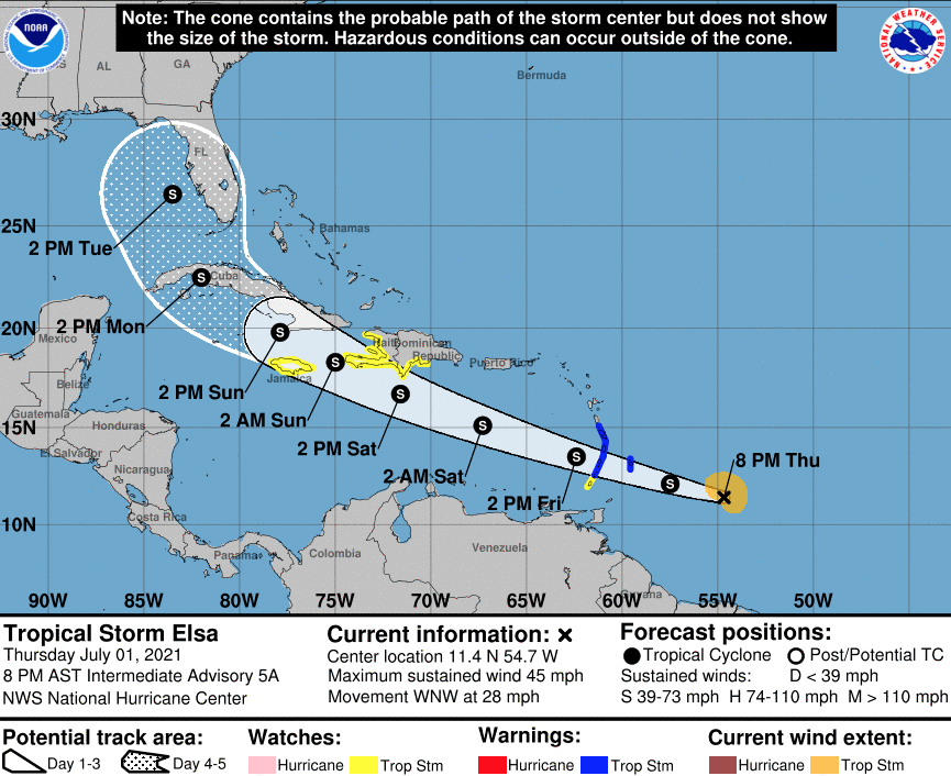
NASSAU, BAHAMAS — Tropical Storm Elsa is expected to pass near or over portions of the Leeward Islands and south of The Bahamas today, bringing heavy rainfall and thunderstorms to the surrounding islands, according to meteorologists.
On its current forecast track, the storm is expected to travel south of Puerto Rico on Saturday afternoon; over eastern Haiti on Saturday afternoon through Sunday; and over portions of Cuba Sunday afternoon through Monday.
Elsa is projected to impact Florida by Tuesday afternoon.
While no direct impact to The Bahamas is expected from the storm, significant shifts of the system to the northeast could put the southern and northwestern islands within the storm’s cone.
A look at the wind span associated with the storm shows the southern and northwest islands within the outermost projected track, meaning there is approximately a five percent chance of those islands receiving winds of around 39 miles per hour, according to the National Hurricane Center.
According to advisories, tropical storm conditions are expected to begin this morning in portions of the Windward Islands and southern Leeward Islands.
It is expected that heavy rainfall from Elsa will move quickly across the islands, including Barbados, and outer rain bands will impact Puerto Rico and southern Hispaniola by Friday and early Saturday respectively.
“There is a risk of wind and rainfall impacts in portions of Cuba, Jamaica, the Turks and Caicos and The Bahamas through early next week,” according to the National Hurricane Center.
“Interest in these areas should monitor Elsa’s progress and updates to the forecast.
“There is a risk of storm surge, wind and rainfall impacts in the Florida Keys and portions of Florida Peninsula early next week.”
However, the center noted the forecast’s uncertainty remains “larger than usual” due to Elsa’s potential interaction with the Greater Antilles this weekend.


