
NASSAU, BAHAMAS – The weather system currently in the Atlantic could impact The Bahamas as a tropical storm “at best”, according to Senior Deputy Director in the Department of Meteorology Jeffrey Simmons.
He spoke to Eyewitness News shortly after 2pm on the current models tracking the system, which has an 80 percent chance of developing into a named storm.
Simmons said he told another media outlet the system could develop into a Category 1 or 2 hurricane; however, that projection was based on yesterday’s modeling and was not a reflection of the current forecast.
“What I said earlier that was based on some of the models; as a matter of fact, as early as yesterday morning,” Simmons said.
“Some of the models were actually putting it to be a minimum hurricane near the eastern Bahamas. That was some time yesterday, into last night.
“Right now, that is not the case.”
He continued: “Yesterday, a lot of models were not in an agreement on this, and so now, the agreement that the models are now coming in agreement with is that it could be at best a tropical storm passing through The Bahamas over the weekend.”
Sustained winds of 74 miles per hour classify a storm as a Category 1 hurricane.
According to the deputy director, the fast-moving system was entering into a “hostile environment”.
He said the Saharan dust plumes in the region, cocooned in areas of dry air, could likely remove moisture from the storm, further weakening it.
“The system is headed into a very hostile environment and its chances of surviving is not so good,” Simmons said.
“They have the system becoming no more than a tropical storm even all the way into Florida, I think sometime on Monday or thereabouts.
“So, the system itself, we expect a weak system; at the best, a tropical storm.”
Simmons said Bahamians should be prepared given the ongoing hurricane season and the early developments of named storms.
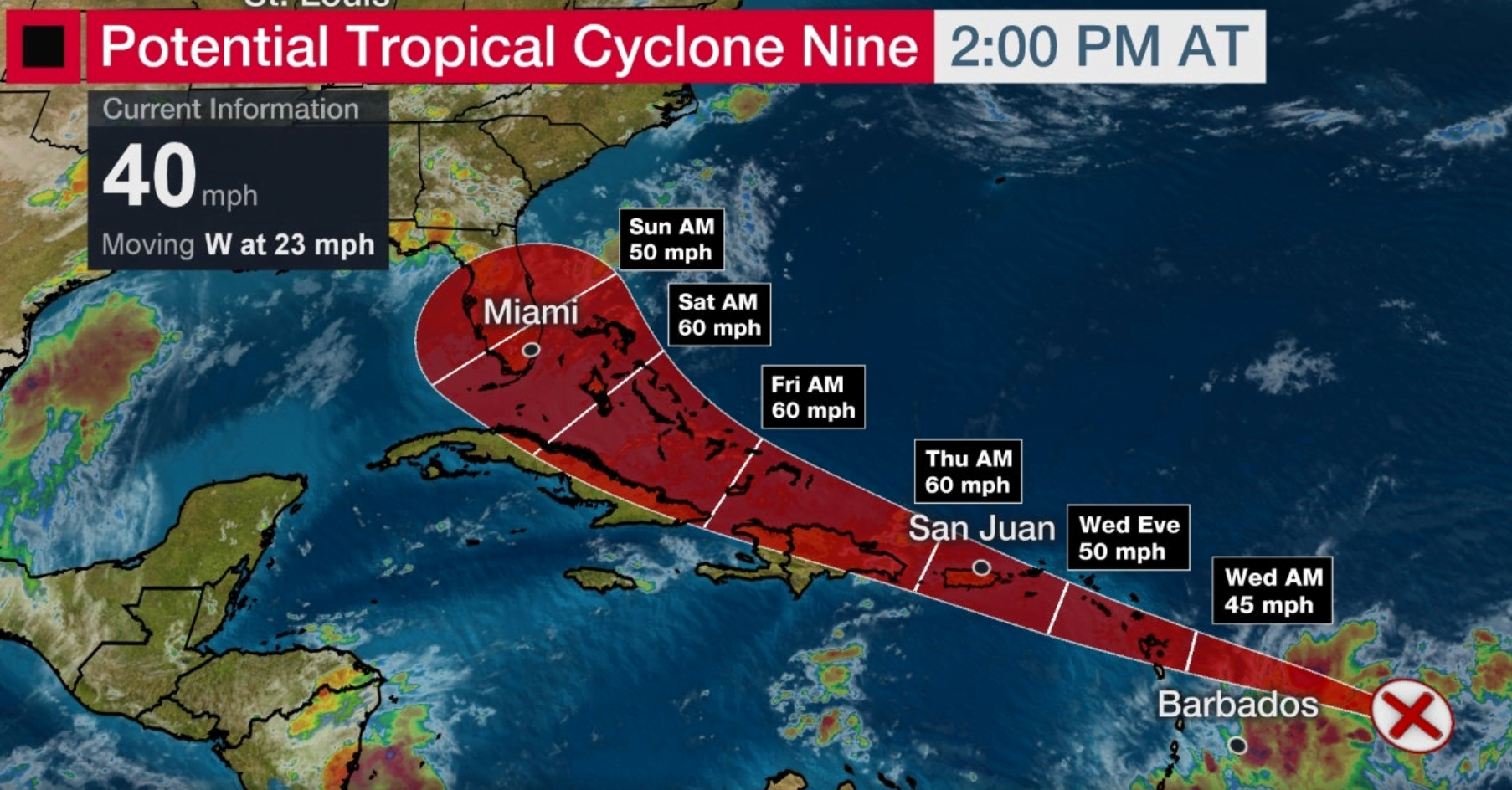
This afternoon, the hurricane center advised some strengthening was expected and the system was projected to become a tropical storm within 48 hours.
As of 2pm, the system was around 510 miles east, southeast of the Leeward Islands.
It had maximum sustained winds of 40 miles per hour.
It was traveling west at 23 miles per hour.
A tropical storm watch is in effect for Dominican Republic.
A tropical storm warning has been issued for Puerto Rico, US Virgin Islands, British Virgin Islands, Antigua, Barbuda, Montserrat, St Kitts and Nevis, Anguilla, Guadeloupe, Martinique, St Martin, St Barthelemy and St Maartin.
“The details of the long-range track and intensity forecasts are more uncertain than usual since the system does not have a well-defined center and could move over portions of the Greater Antilles later this week,” the center said.
“However, this system could bring some rainfall and wind impacts to portions of Hispaniola, Cuba, The Bahamas, and Florida by the end of the week. Interests there should monitor its progress and updates to the forecast over the next few days.”


